That Color on the Map Does Not Tell Me Enough About a House
By Arthur · An illustrated owner’s guide
I like a useful map. I also want the legend, the written rules and a little less guesswork.
For entertainment and general understanding. These illustrations and questions are not legal advice, an electrical design, a construction specification or a site-specific professional assessment.
One solid patch of color on a planning map can look wonderfully reassuring. I would be tempted to follow it across the screen and think, “Well, that seems straightforward.” Then I would read the legend and see whether my confidence survives the introduction.
I like a useful map. I just want to understand what it is telling me before I supply an answer of my own.
A planning map helps me find the next question. To understand what it means for a house, I want its legend, its written rules and a reliable connection to the actual parcel. Here is how I would prepare for that conversation with a local planner or architect. This is a reading guide, not a legal opinion or a determination that land is buildable.
A planning conversation with an abstract map. Verify parcel details and zoning with the relevant authorities.
Start with who made the map and where it applies
Before looking at the property, I would read the title. Which district or other jurisdiction does this document cover? Who issued it? Is it an adopted planning instrument, a proposal, a historical sheet or a reference viewer?
MIVIOT’s public repository specifically warns that zoning, easement and building-line graphics are referential and may have changed. It directs users to the competent urban authority for certification for official procedures. That warning belongs beside the map, not at the bottom of my memory. MIVIOT repository notice ↗ (opens in a new tab)
I would record three dates if available: the instrument’s approval date, the layer or drawing’s update date, and the date I consulted it. A website updated recently can host an older document. If an approval reference or amendment history is missing, that becomes a question for the authority rather than a gap I fill with optimism.
Read the legend before naming the color
A color needs its code and definition. A pale green patch might be a planning category, a background feature or a layer I have not understood. I would inspect the legend, labels and active layers before calling it anything.
Panamá district provides a concrete example of why the written companion matters. Its published Annex 5 regulation matrix uses different symbols for “vocacionales,” “permitidos” and “prohibido.” I would preserve those distinctions and ask how the relevant terms operate, rather than translate every friendly-looking mark into “approved.” Panamá PLOT Annex 5, page 2 ↗ (opens in a new tab)
That downloadable file sits under a 2021 upload path. I am using it to show how to read a document, not claiming it is the complete current rulebook for any parcel in November 2026. The municipality must confirm applicable versions and changes.
Zooming in does not improve the underlying evidence
I would look for the scale, coordinate reference information and stated limits of the mapping. Enlarging a regional map makes the symbols bigger; it does not magically turn them into surveyed boundaries.
For a printed sheet, I would check whether it has been resized before treating a printed scale as usable. In a digital viewer, I would keep the layer information with any observation. A road visible in aerial imagery and a road reservation drawn in a planning layer may represent different things.
Suppose a boundary runs close to the corner of a proposed house site. I would ask the survey professional and planning authority to resolve where it falls. Measuring a few pixels until I get the answer I prefer would be a surprisingly modern way to fool myself.
Panamá’s published 2024 certification form illustrates the importance of location and purpose: it asks for locality information, the reason for the request and graphical references, with cadastral plans and coordinates among the listed options. It is an example from that municipality and year, not a promise about today’s filing requirements. DPU certification form ↗ (opens in a new tab)
If the parcel crosses a mapped boundary, I would write that down explicitly. If documents disagree, I would retain both and ask for reconciliation.
Ask what sits over or beside the base zoning
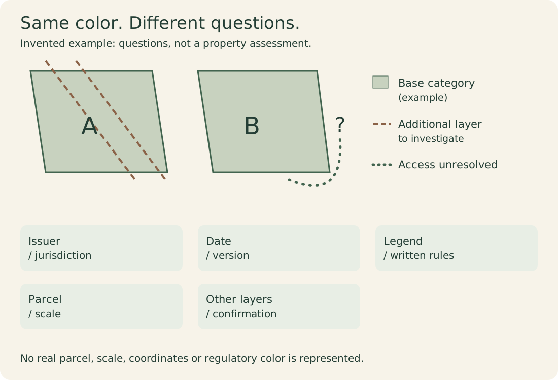
Here is a completely invented example. Two parcels share the same base color. One also appears to intersect a water-related constraint layer; the other has an unresolved access route. The matching color gives me no basis to say their development prospects are identical.
For a real site, I would ask about relevant protection areas, watercourses, road reservations, easements, hazard information and special planning provisions. Which are binding, which are indicative, and which require further investigation? A missing layer on my screen would remain an information gap.
Panamá’s DPU pages link separately to flood-zone information and a Law 21 map. Its Annex 5 also refers national protected-area regulation to MiAmbiente management plans. Those are useful reminders to follow cross-references; they do not establish that any particular restriction applies to your land. DPU document index ↗ (opens in a new tab) · Annex 5, page 6 ↗ (opens in a new tab)
Read the rule attached to the exact proposal
I would describe the intended use honestly: one household, separate dwellings, guest accommodation or a business. Then ask which definition fits. A pleasant residential label cannot answer every question about how a property will operate.
Where applicable, I would have the designer identify the relevant dimensions, setbacks, height, coverage and other conditions in the governing text, including footnotes and exceptions. I would ask where each answer comes from. I have not verified a current consolidated set of numeric limits for this article, so there are none to borrow here.
I would bring these questions:
What I would ask before trusting the map
Map-reading question
What I would request
What stays unresolved without it
Which instrument applies?
Jurisdiction, approval reference and amendments
Whether this is the governing version
What does the code mean?
Legend and corresponding written provisions
Compatibility of the intended use
Is this the right parcel?
Reconciled identification and survey information
Exact boundary relationships
Are other layers relevant?
Applicable constraints and their authority
Restrictions beyond base zoning
Who confirms the interpretation?
Property-specific response or certification
Reliance on an indicative map
Same color. Different questions.
Invented example: questions, not a property assessment. Shapes A and B share an example base category. A has an additional dashed layer; B has a dotted, unresolved access question.
Issuer / jurisdiction
Who made the map, and where does it apply?
Date / version
Which version and amendments are current?
Legend / written rules
What do the symbols and companion text mean?
Parcel / scale
Does the mapped location match the actual parcel?
Other layers / confirmation
What else applies, and who can confirm it?
All shapes and categories are invented. Obtain property-specific professional and authority advice; this is not a survey or zoning decision.
All shapes and categories are invented. Obtain property-specific professional and authority advice; this is not a survey or zoning decision.
Finish with a better question than “Can I build?”
Panamá’s DPU explicitly says its zoning graphics are reference information and calls for municipal certification for official or private procedures. Separately, DOYC describes the construction-permit process. I would keep that distinction clear: a zoning answer does not complete the work needed to authorize construction. DPU notice ↗ (opens in a new tab) · DOYC permit description ↗ (opens in a new tab)
My next question would be: “For this identified parcel and this proposed use, which current provisions apply, and what remains to be checked?” Ownership, access, services, ground conditions and environmental requirements still need their appropriate reviews.
I like that outcome better than a confident guess. The map has helped me prepare a useful conversation, and the living-room furniture can wait until the land has had its say.
Sources behind the questions
Research checked 2026-11-08. External source links open in a new tab. Foreign sources explain principles, not Panama project requirements. Local examples do not replace confirmation for the property.